Owl Mountain Jeep Trail

Owl Mountain Jeep Trail

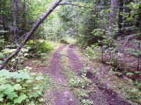
This rugged trail is shaped by steep terrain, aging timber, and frequent deadfall that can block the route year-round. Volunteers from the Tri-County Motorized Recreation Association clear the trail several times each season, generally opening passage for short-wheelbase vehicles up to 72 inches wide. Wider vehicles may encounter tight turns, dense brush, and lingering obstacles.

Challenging pitches and overgrowth make this a moderate trail for Jeeps and larger OHVs and a difficult route for low-clearance vehicles and ATVs. Most obstacles do not have bypasses, so come prepared with a spare tire, recovery gear, and basic repair tools.

Near the northern end, a scenic viewpoint at N48.9774 W118.273 provides a perfect lunch stop with sweeping views east, south, and west, along with additional overlooks offering striking views north into Canada.

If enjoying these trails on a motorized vehicle, please make sure you are carrying a current Motor Vehicle Use Map. See below for more information.

Owl Mountain Jeep Trail

Difficulty Level:
This Trail is Suitable for:
Trail Activities:
Trail Amenities::

Motorized vehicle users: Make sure you have your MVUM with you!

Motor Vehicle Use Maps (MVUM) are the official maps for designating all roads and trails available for public motorized travel on the Colville National Forest. Visitors should not rely on any other map for making decisions about motorized travel. A MVUM is a legally enforceable document that identifies the roads, trails, and areas where motor vehicle use is allowed in a Forest Service administrative unit or ranger district. Forest User Maps combine information from the Motor Vehicle Use Maps and firewood cutting information. This provides a single map that includes the necessary information you will need to navigate the forest for recreation, firewood cutting, and other adventures.